Geolocate

Tamarindo topographic map

Click on the map to display elevation.

Tamarindo

Tamarindo has an area of 125.86 square kilometres (48.59 sq mi) and an elevation of 27 metres (89 ft).

Wikipedia (CC-BY-SA 3.0)

About this map

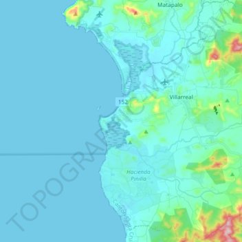
Name: Tamarindo topographic map, elevation, terrain.

Location: Tamarindo, Cantón de Santa Cruz, Guanacaste, 50309, Costa Rica (10.22045 -85.85496 10.36423 -85.74187)

Average elevation: 89 ft

Minimum elevation: 0 ft

Maximum elevation: 991 ft

Other topographic maps

Click on a map to view its topography, its elevation and its terrain.

Laguna

Costa Rica > Cantón de Santa Cruz > Tamarindo

Average elevation: 171 ft

Marbella

Costa Rica > Cantón de Santa Cruz > Cuajiniquil

Average elevation: 108 ft

Hernández

Costa Rica > Cantón de Santa Cruz > Tamarindo

Average elevation: 164 ft

Gear up for your next adventure:

🛡️Bear Spray Outdoor - Protection in bear country hikes
🪶Fire Starter Kit - Reliable fire starter for survival and camping
🦟Ultrasonic Repellers - Create a bug-free zone at your camp or rest stop
🛏️Cold Weather Sleeping Bag - Warm sleeping bag for cold conditions
🪶Camping Sleeping Pad - Comfortable sleeping pad for backpacking

As an Amazon Associate, this site earns from qualifying purchases at no extra cost to you.