
Purísima de Bustos topographic map
Interactive map
Click on the map to display elevation.
About this map
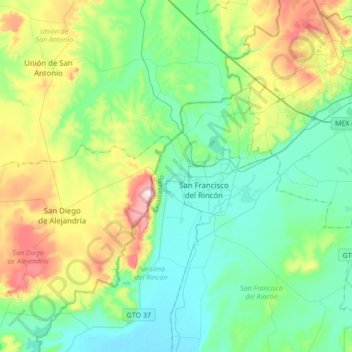
Name: Purísima de Bustos topographic map, elevation, terrain.
Average elevation: 5,991 ft
Minimum elevation: 5,732 ft
Maximum elevation: 7,234 ft
Other topographic maps
Click on a map to view its topography, its elevation and its terrain.
Cañada de Negros
México > Guanajuato > Purísima del Rincón > Cañada de Negros
Cañada de Negros, Purísima del Rincón, Guanajuato, 36420, México
Average elevation: 5,906 ft
San Angel
México > Guanajuato > Purísima del Rincón
San Angel, Purísima del Rincón, Guanajuato, 36435, México
Average elevation: 5,794 ft