Geolocate

Irving topographic map

Click on the map to display elevation.

About this map

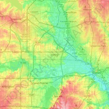
Name: Irving topographic map, elevation, terrain.

Location: Irving, Dallas County, Texas, 75061, United States (32.66952 -97.10422 32.98952 -96.78422)

Average elevation: 531 ft

Minimum elevation: 384 ft

Maximum elevation: 764 ft

Dallas County trails, hiking, mountain biking, running and outdoor activities

Other topographic maps

Click on a map to view its topography, its elevation and its terrain.

Gear up for your next adventure:

🎁Geography Themed Gifts - Unique gift ideas for map lovers and geography enthusiasts
🛰️Handheld GPS Units - Professional satellite navigators for precise backcountry mapping
🪵Folding Camp Saw - Compact saw for wood and campsite work
🩳Quick‑Dry Hiking Shorts - Comfortable and quick‑dry shorts for summer hiking
☀️Outdoor Sunscreen - High protection sunscreen for outdoor activities

As an Amazon Associate, this site earns from qualifying purchases at no extra cost to you.