
Concepcion topographic map
Click on the map to display elevation.
About this map
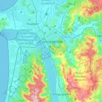
Name: Concepcion topographic map, elevation, terrain.
Location: Concepcion, Provincia de Concepción, Biobio Region, Chile (-36.92681 -73.09159 -36.76442 -72.84462)
Average elevation: 338 ft
Minimum elevation: 0 ft
Maximum elevation: 1,640 ft
Other topographic maps
Click on a map to view its topography, its elevation and its terrain.
Agua de la Gloria
Chile > Biobío Region > Provincia de Concepción > Concepcion > El Pino
Average elevation: 308 ft
Casa Poli
Chile > Biobío Region > Provincia de Concepción > Dichato > Camino a Los Cerezos Bajo
Average elevation: 89 ft