
Make a donation
Gear up for your next adventure:
As an Amazon Associate, this site earns from qualifying purchases at no extra cost to you.
Fair Haven topographic map
Click on the map to display elevation.
Make a donation
Gear up for your next adventure:
As an Amazon Associate, this site earns from qualifying purchases at no extra cost to you.
About this map
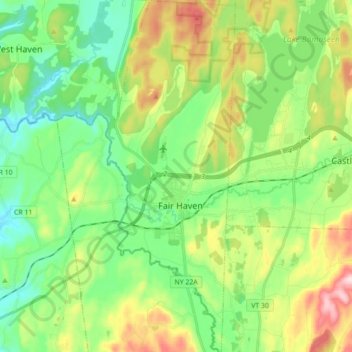
Name: Fair Haven topographic map, elevation, terrain.
Location: Fair Haven, Rutland County, Vermont, United States (43.53967 -73.30327 43.66890 -73.23856)
Average elevation: 463 ft
Minimum elevation: 95 ft
Maximum elevation: 1,178 ft
Rutland County trails, hiking, mountain biking, running and outdoor activities
Make a donation
Gear up for your next adventure:
As an Amazon Associate, this site earns from qualifying purchases at no extra cost to you.
Other topographic maps
Click on a map to view its topography, its elevation and its terrain.
Make a donation
Gear up for your next adventure:
As an Amazon Associate, this site earns from qualifying purchases at no extra cost to you.
Make a donation
Gear up for your next adventure:
As an Amazon Associate, this site earns from qualifying purchases at no extra cost to you.
Billings Mobile Manor
United States > Vermont > Rutland County > Rutland City
Average elevation: 692 ft
Make a donation
Gear up for your next adventure:
As an Amazon Associate, this site earns from qualifying purchases at no extra cost to you.
West Tinmouth
United States > Vermont > Rutland County > Tinmouth > West Tinmouth
Average elevation: 1,375 ft
Chittenden Reservoir
United States > Vermont > Rutland County > Chittenden
Average elevation: 1,552 ft