
Make a donation
Gear up for your next adventure:
As an Amazon Associate, this site earns from qualifying purchases at no extra cost to you.
Arsita topographic map
Click on the map to display elevation.
Make a donation
Gear up for your next adventure:
As an Amazon Associate, this site earns from qualifying purchases at no extra cost to you.
Arsita
Arsita is a communal capital in the Province of Teramo in the Abruzzo Region of Italy. Arsita is located at an elevation of 470 metres (1,540 ft) 36 kilometres (22 mi) from Teramo.
Make a donation
Gear up for your next adventure:
As an Amazon Associate, this site earns from qualifying purchases at no extra cost to you.
About this map
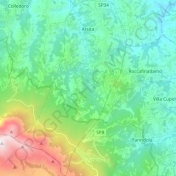
Name: Arsita topographic map, elevation, terrain.
Location: Arsita, Teramo, Abruzzo, 64031, Italy (42.42112 13.72771 42.51799 13.81155)
Average elevation: 2,451 ft
Minimum elevation: 686 ft
Maximum elevation: 8,346 ft
Make a donation
Gear up for your next adventure:
As an Amazon Associate, this site earns from qualifying purchases at no extra cost to you.
Other topographic maps
Click on a map to view its topography, its elevation and its terrain.
Make a donation
Gear up for your next adventure:
As an Amazon Associate, this site earns from qualifying purchases at no extra cost to you.
Make a donation
Gear up for your next adventure:
As an Amazon Associate, this site earns from qualifying purchases at no extra cost to you.