Geolocate

Canlaon topographic map

Click on the map to display elevation.

About this map

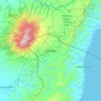
Name: Canlaon topographic map, elevation, terrain.

Location: Canlaon, Negros Oriental, Central Visayas, 6223, Philippines (10.22695 123.05862 10.54695 123.37862)

Average elevation: 1,417 ft

Minimum elevation: -7 ft

Maximum elevation: 7,969 ft

Other topographic maps

Click on a map to view its topography, its elevation and its terrain.

Cantil-e

Philippines > Negros Oriental > Dumaguete

Average elevation: 253 ft

La Paz

Philippines > Negros Oriental > Bais

Average elevation: 49 ft

Sibulan

Philippines > Negros Oriental

Average elevation: 712 ft

Lake Balinsasayao

Philippines > Negros Oriental > Sibulan

Average elevation: 3,169 ft

Gear up for your next adventure:

🛠️Outdoor Gear Repair Kit - Essential tools to fix gear on the trail
🧦Merino Wool Socks - Moisture-wicking, blister-preventing socks for long treks
🥾Hiking Shoes - Durable and comfortable shoes for trail hiking
🔥Fast-Boil Camping Stoves - Efficient cooking systems for quick trail meals
🎒Hydration Pack - Hands‑free water reservoir for long hikes

As an Amazon Associate, this site earns from qualifying purchases at no extra cost to you.