
Timmenrode topographic map
Interactive map
Click on the map to display elevation.
About this map
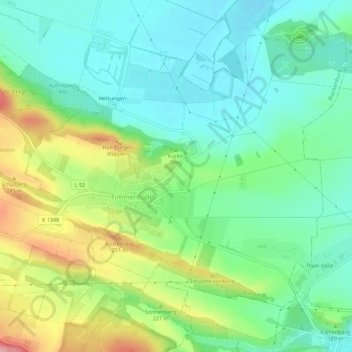
Name: Timmenrode topographic map, elevation, terrain.
Average elevation: 627 ft
Minimum elevation: 486 ft
Maximum elevation: 915 ft
Other topographic maps
Click on a map to view its topography, its elevation and its terrain.
Börnecke
Deutschland > Sachsen-Anhalt > Landkreis Harz > Blankenburg
Börnecke, Blankenburg, Landkreis Harz, Sachsen-Anhalt, Deutschland
Average elevation: 558 ft
Teufelsmauer
Deutschland > Sachsen-Anhalt > Landkreis Harz > Blankenburg
Teufelsmauer, Blankenburg, Landkreis Harz, Sachsen-Anhalt, 38889, Deutschland
Average elevation: 738 ft
Börnecke
Deutschland > Sachsen-Anhalt > Landkreis Harz > Blankenburg
Börnecke, Blankenburg, Landkreis Harz, Sachsen-Anhalt, Deutschland
Average elevation: 577 ft
Ziegenkopf
Deutschland > Sachsen-Anhalt > Landkreis Harz > Blankenburg
Ziegenkopf, Blankenburg, Landkreis Harz, Sachsen-Anhalt, 38889, Deutschland
Average elevation: 1,086 ft
Volkmarskeller
Deutschland > Sachsen-Anhalt > Landkreis Harz > Blankenburg
Volkmarskeller, Heimburg, Blankenburg, Landkreis Harz, Sachsen-Anhalt, 38889, Deutschland
Average elevation: 1,509 ft
Blankenstein
Deutschland > Sachsen-Anhalt > Landkreis Harz > Blankenburg
Blankenstein, Blankenburg, Landkreis Harz, Sachsen-Anhalt, 38889, Deutschland
Average elevation: 876 ft
Hüttenrode
Deutschland > Sachsen-Anhalt > Landkreis Harz > Blankenburg
Hüttenrode, Blankenburg, Landkreis Harz, Sachsen-Anhalt, 38889, Deutschland
Average elevation: 1,430 ft
Heimburg
Deutschland > Sachsen-Anhalt > Landkreis Harz > Blankenburg
Heimburg, Blankenburg, Landkreis Harz, Sachsen-Anhalt, Deutschland
Average elevation: 988 ft