
La Puebla de Fantova topographic map
Interactive map
Click on the map to display elevation.
About this map
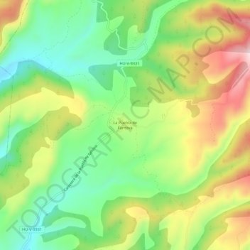
Name: La Puebla de Fantova topographic map, elevation, terrain.
Location: La Puebla de Fantova, Graus, La Ribagorza, Huesca, Aragon, Spain (42.23913 0.37774 42.27913 0.41774)
Average elevation: 2,254 ft
Minimum elevation: 1,759 ft
Maximum elevation: 2,940 ft
Other topographic maps
Click on a map to view its topography, its elevation and its terrain.
Graus
Spain > Aragon > La Ribagorza > Graus
Graus, La Ribagorza, Huesca, Aragon, 22430, Spain
Average elevation: 2,329 ft