
Make a donation
Gear up for your next adventure:
As an Amazon Associate, this site earns from qualifying purchases at no extra cost to you.
Santo Tirso topographic map
Click on the map to display elevation.
Make a donation
Gear up for your next adventure:
As an Amazon Associate, this site earns from qualifying purchases at no extra cost to you.
Santo Tirso
The highest point in the municipality is in the Alto de S. Jorge, in the parish of Refojos, with 527 meters of altitude. The municipality's current perimeter is 69 kilometres (43 miles).
Make a donation
Gear up for your next adventure:
As an Amazon Associate, this site earns from qualifying purchases at no extra cost to you.
About this map
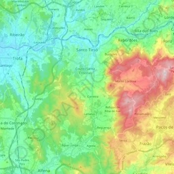
Name: Santo Tirso topographic map, elevation, terrain.
Location: Santo Tirso, Porto, Portugal (41.23807 -8.51985 41.38429 -8.31645)
Average elevation: 607 ft
Minimum elevation: 75 ft
Maximum elevation: 1,857 ft
Make a donation
Gear up for your next adventure:
As an Amazon Associate, this site earns from qualifying purchases at no extra cost to you.
Other topographic maps
Click on a map to view its topography, its elevation and its terrain.