
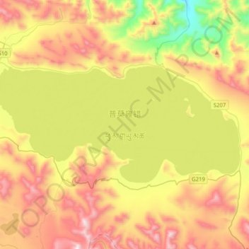
普莫雍错 topographic map
Interactive map
Click on the map to display elevation.
About this map
Name: 普莫雍错 topographic map, elevation, terrain.
Location: 普莫雍错, 普玛江塘乡, 浪卡子县, 山南市, 西藏自治区, 中国 (28.49622 90.23250 28.62475 90.54525)
Average elevation: 16,749 ft
Minimum elevation: 14,783 ft
Maximum elevation: 18,983 ft
普莫雍错(藏语:ཕུ་མ་གཡུ་མཚོ,威利:phu ma g.yu mtsho)位于中国西藏自治区南部浪卡子县普马江塘乡境内,地处羊卓雍错西南,拉萨市西南135公里。面积295平方公里,湖面海拔4733米(另有“面积284平方公里,湖面海拔5010米”等多种数据)。主要由高山雪水补给,湖泊沿岸为优良牧场。
Other topographic maps
Click on a map to view its topography, its elevation and its terrain.