
Kilmington topographic map
Interactive map
Click on the map to display elevation.
About this map
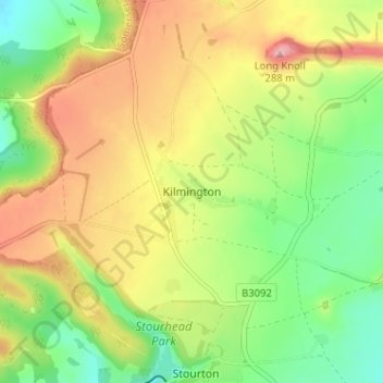
Name: Kilmington topographic map, elevation, terrain.
Average elevation: 653 ft
Minimum elevation: 430 ft
Maximum elevation: 919 ft
Other topographic maps
Click on a map to view its topography, its elevation and its terrain.
Kilmington
United Kingdom > England > Kilmington
Kilmington, Devon, South West England, England, EX13 7RR, United Kingdom
Average elevation: 197 ft