Geolocate

Great Lake topographic map

Click on the map to display elevation.

About this map

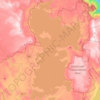
Name: Great Lake topographic map, elevation, terrain.

Location: Great Lake, Central Highlands, Tasmania, Australia (-41.98965 146.67653 -41.77300 146.83415)

Average elevation: 3,593 ft

Minimum elevation: 1,719 ft

Maximum elevation: 4,564 ft

Other topographic maps

Click on a map to view its topography, its elevation and its terrain.

Cathedral Mountain

Australia > Tasmania

Average elevation: 3,255 ft

Waterworks Reserve

Australia > Tasmania > Hobart

Average elevation: 787 ft

Rowlands Hill

Australia > Tasmania

Average elevation: 1,273 ft

Cradle Mountain

Australia > Tasmania > Cradle Mountain

Average elevation: 3,753 ft

The Nut

Australia > Tasmania > Stanley

Average elevation: 26 ft

Bream Creek

Australia > Tasmania > Bream Creek

Average elevation: 115 ft

Buxton Point

Australia > Tasmania > Little Swanport

Average elevation: 10 ft

Mount Patrick

Australia > Tasmania

Average elevation: 2,831 ft

Mount Ossa

Australia > Tasmania

Average elevation: 3,996 ft

West Gawler River

Australia > Tasmania > Sprent > Gawler

Average elevation: 659 ft

Mount Tyndall

Australia > Tasmania

Average elevation: 2,986 ft

Gear up for your next adventure:

📶Satellite Messenger - Communication device off‑grid
🔭Compact Binoculars - HD vision for scouting terrain and identifying distant landmarks
🧭Orienteering Set - Complete compass and map reading kit
🔋Solar Power Banks - Keep your GPS and phone charged in remote wilderness areas
🪶Fire Starter Kit - Reliable fire starter for survival and camping

As an Amazon Associate, this site earns from qualifying purchases at no extra cost to you.