
Necanicum River topographic map
Interactive map
Click on the map to display elevation.
About this map
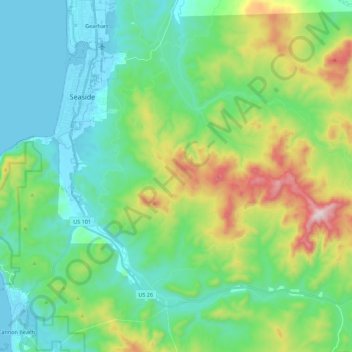
Name: Necanicum River topographic map, elevation, terrain.
Average elevation: 607 ft
Minimum elevation: -7 ft
Maximum elevation: 2,320 ft
The Necanicum River rises south of Humbug Mountain (not to be confused with the Humbug Mountain in southwestern Oregon), in south central Clatsop County and south of the Saddle Mountain State Natural Area. The elevation of the river's source is approximately 1,847 feet (563 m). It flows generally west, along U.S. Route 26. Approximately 3 miles (4.8 km) from the coast, east of Tillamook Head, it turns north. The river enters the Pacific Ocean at Seaside. Its final approach to the ocean is nearly parallel to the coast running south to north through the downtown of Seaside.
Other topographic maps
Click on a map to view its topography, its elevation and its terrain.
Cascade Range
United States of America > Oregon
Cascade Range, Marion County, Oregon, United States of America
Average elevation: 2,264 ft
Springfield
United States of America > Oregon > Springfield > Springfield
Springfield, Lane County, Oregon, 97477-2635, United States of America
Average elevation: 741 ft
Washington Park
United States of America > Oregon > Portland
Washington Park, 4033, Arlington Heights, Portland, Multnomah County, Oregon, 97221, United States of America
Average elevation: 554 ft
Imnaha River Woods Development
United States of America > Oregon > Imnaha River Woods Development
Imnaha River Woods Development, Wallowa County, Oregon, United States of America
Average elevation: 4,367 ft
Crescent Lake
United States of America > Oregon > Crescent Lake
Odell Lake, Crescent Lake, Klamath County, Oregon, United States of America
Average elevation: 4,895 ft
Pine Point
United States of America > Oregon
Pine Point, Curry County, Oregon, United States of America
Average elevation: 1,158 ft
The Villages at Mount Hood
United States of America > Oregon
The Villages at Mount Hood, Clackamas County, Oregon, United States of America
Average elevation: 2,615 ft
Charleston
United States of America > Oregon > Charleston
Charleston, Coos County, Oregon, United States of America
Average elevation: 79 ft
The Peaks
United States of America > Oregon
The Peaks, Harney County, Oregon, United States of America
Average elevation: 5,988 ft
Riddle
United States of America > Oregon > Riddle
Riddle, Douglas County, Oregon, United States of America
Average elevation: 807 ft
Scholls
United States of America > Oregon > Scholls
Scholls, Washington County, Oregon, United States of America
Average elevation: 171 ft
Buxton
United States of America > Oregon > Buxton
Buxton, Washington County, Oregon, 97125, United States of America
Average elevation: 479 ft
Iron Knob
United States of America > Oregon
Iron Knob, Jackson County, Oregon, United States of America
Average elevation: 2,825 ft
Cape Blanco
United States of America > Oregon
Cape Blanco, Cape Blanco Road, Curry County, Oregon, United States of America
Average elevation: 30 ft
Tierra Del Mar
United States of America > Oregon > Tierra Del Mar
Tierra Del Mar, Tillamook County, Oregon, 97135, United States of America
Average elevation: 220 ft
Horse Ridge
United States of America > Oregon
Horse Ridge, Deschutes County, Oregon, United States of America
Average elevation: 4,560 ft
Table Rock
United States of America > Oregon > Brookings
Table Rock, Brookings, Curry County, Oregon, 97415, United States of America
Average elevation: 794 ft
Lebanon Dam
United States of America > Oregon
Lebanon Dam, Linn County, Oregon, United States of America
Average elevation: 489 ft
Boring
United States of America > Oregon > Boring
Boring, Clackamas County, Oregon, 97009, United States of America
Average elevation: 600 ft
Upper Highland
United States of America > Oregon > Upper Highland
Upper Highland, Clackamas County, Oregon, United States of America
Average elevation: 1,198 ft
Tick Hill
United States of America > Oregon
Tick Hill, Wallowa County, Oregon, 97885, United States of America
Average elevation: 3,248 ft
Tillamook
United States of America > Oregon > Tillamook > Tillamook
Tillamook, Tillamook County, Oregon, United States of America
Average elevation: 13 ft