Geolocate

Brechfa topographic map

Click on the map to display elevation.

About this map

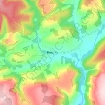
Name: Brechfa topographic map, elevation, terrain.

Location: Brechfa, Carmarthenshire, Wales, SA32 7QZ, United Kingdom (51.93237 -4.16875 51.97237 -4.12875)

Average elevation: 554 ft

Minimum elevation: 161 ft

Maximum elevation: 1,063 ft

Other topographic maps

Click on a map to view its topography, its elevation and its terrain.

River Towy

United Kingdom > Wales > Carmarthenshire

Average elevation: 705 ft

Gear up for your next adventure:

🦶Hiking Gaiters - Keep debris and water out of your boots
🌧️Backpack Rain Cover - Keep gear dry in wet weather
🕶️GPS Smartphone Mount - Secure mount for phone navigation
🩳Quick‑Dry Hiking Shorts - Comfortable and quick‑dry shorts for summer hiking
📱Heavy-Duty Phone Cases - Drop-proof and waterproof protection for outdoor navigation

As an Amazon Associate, this site earns from qualifying purchases at no extra cost to you.