
Feudingen topographic map
Interactive map
Click on the map to display elevation.
About this map
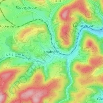
Name: Feudingen topographic map, elevation, terrain.
Average elevation: 1,542 ft
Minimum elevation: 1,204 ft
Maximum elevation: 2,008 ft
Other topographic maps
Click on a map to view its topography, its elevation and its terrain.
Feudingerhütte
Deutschland > Nordrhein-Westfalen > Kreis Siegen-Wittgenstein > Bad Laasphe > Feudingen
Feudingerhütte, Feudingen, Bad Laasphe, Kreis Siegen-Wittgenstein, Nordrhein-Westfalen, 57334, Deutschland
Average elevation: 1,526 ft