
Brotterode topographic map
Interactive map
Click on the map to display elevation.
About this map
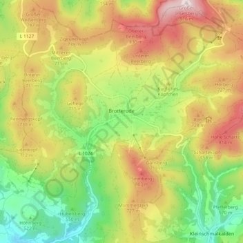
Name: Brotterode topographic map, elevation, terrain.
Average elevation: 2,093 ft
Minimum elevation: 1,312 ft
Maximum elevation: 3,009 ft
Other topographic maps
Click on a map to view its topography, its elevation and its terrain.
Trusetal
Deutschland > Thüringen > Landkreis Schmalkalden-Meiningen > Brotterode-Trusetal
Trusetal, Brotterode-Trusetal, Landkreis Schmalkalden-Meiningen, Thüringen, 98596, Deutschland
Average elevation: 1,401 ft