Geolocate

Merching topographic map

Click on the map to display elevation.

About this map

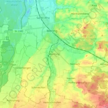
Name: Merching topographic map, elevation, terrain.

Location: Merching, Landkreis Aichach-Friedberg, Bavaria, 86504, Germany (48.22228 10.90751 48.26742 11.05884)

Average elevation: 1,739 ft

Minimum elevation: 1,627 ft

Maximum elevation: 1,919 ft

Other topographic maps

Click on a map to view its topography, its elevation and its terrain.

Haunswies

Germany > Bavaria > Landkreis Aichach-Friedberg

Average elevation: 1,644 ft

Pichl

Germany > Bavaria > Landkreis Aichach-Friedberg

Average elevation: 1,565 ft

Lindl

Germany > Bavaria > Landkreis Aichach-Friedberg

Average elevation: 1,604 ft

Gear up for your next adventure:

🧣Hiking Neck Gaiter - Multi‑use neck protection for outdoor weather
🧯Portable Fire Pit - Compact fire pit for camping spots
🔊Portable Camp Speaker - Music and alerts at camp
🚪Portable Camp Chair - Foldable chair for comfort at camp
🪶Compact Camp Shovel - Folding shovel for campsite tasks

As an Amazon Associate, this site earns from qualifying purchases at no extra cost to you.