
Malaita topographic map
Interactive map
Click on the map to display elevation.
About this map
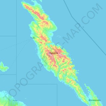
Name: Malaita topographic map, elevation, terrain.
Location: Malaita, Solomon Islands (-9.59809 160.55900 -8.31227 161.41064)
Average elevation: 174 ft
Minimum elevation: -7 ft
Maximum elevation: 4,140 ft
Malaitan hydrology includes thousands of small springs, rivulets, and streams, characteristic of a young drainage pattern. At higher altitudes waterfalls are common, and in some places canyons have been cut through the limestone. Nearer the coasts, rivers are slower and deeper, and form mangrove swamps of brackish water, along with alluvial deposits of gravel, sand, or mud. The coastal plain is very narrow. Inland soils are of three types, wet black, dry black, and red. The wet black soil, too poorly drained for most horticulture except taro, is found in valleys or at the foot of slopes. Dry black makes the best gardening sites. The red soil, probably laterite, does not absorb runoff and forms a hard crust, and is preferred for settlement sites.