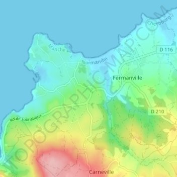
Le Tôt de Haut topographic map
Interactive map
Click on the map to display elevation.
About this map
Name: Le Tôt de Haut topographic map, elevation, terrain.
Average elevation: 108 ft
Minimum elevation: -3 ft
Maximum elevation: 440 ft

Click on the map to display elevation.
Name: Le Tôt de Haut topographic map, elevation, terrain.
Average elevation: 108 ft
Minimum elevation: -3 ft
Maximum elevation: 440 ft