
Theog topographic map
Interactive map
Click on the map to display elevation.
About this map
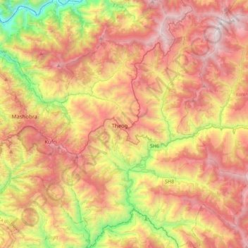
Name: Theog topographic map, elevation, terrain.
Location: Theog, Shimla, Himachal Pradesh, India (30.97466 77.26562 31.26835 77.53648)
Average elevation: 6,457 ft
Minimum elevation: 2,152 ft
Maximum elevation: 10,456 ft
Other topographic maps
Click on a map to view its topography, its elevation and its terrain.
Nani
India > Himachal Pradesh > Theog > Matiana
Nani, Matiana, Theog, Shimla District, Himachal Pradesh, 171212, India
Average elevation: 8,301 ft
Kharaban
India > Himachal Pradesh > Theog > Kangar
Kharaban, Kangar, Theog, Shimla District, Himachal Pradesh, India
Average elevation: 7,539 ft
Fagu
India > Himachal Pradesh > Theog
Fagu, Theog, Shimla district, Himachal Pradesh, 171209, India
Average elevation: 7,293 ft