
Kerns topographic map
Interactive map
Click on the map to display elevation.
About this map
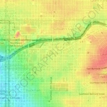
Name: Kerns topographic map, elevation, terrain.
Average elevation: 144 ft
Minimum elevation: 36 ft
Maximum elevation: 226 ft
Other topographic maps
Click on a map to view its topography, its elevation and its terrain.
Hosford-Abernethy
États-Unis d'Amérique > Oregon > Portland
Hosford-Abernethy, Portland, Multnomah County, Oregon, États-Unis d'Amérique
Average elevation: 85 ft
Bridlemile
États-Unis d'Amérique > Oregon > Portland
Bridlemile, Portland, Multnomah County, Oregon, 97221, États-Unis d'Amérique
Average elevation: 489 ft