
Falan topographic map
Interactive map
Click on the map to display elevation.
About this map
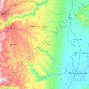
Name: Falan topographic map, elevation, terrain.
Location: Falan, Norte, Tolima, RAP Eje Cafetero, Colombia (5.00187 -75.06487 5.17524 -74.88168)
Average elevation: 2,749 ft
Minimum elevation: 794 ft
Maximum elevation: 6,178 ft
Other topographic maps
Click on a map to view its topography, its elevation and its terrain.
Villahermosa
Colombia > Tolima > Villahermosa
Villahermosa, Nevados, Tolima, Colombia
Average elevation: 6,617 ft
Perímetro Urbano Ibagué
Colombia > Tolima > Ibagué > Perímetro Urbano Ibagué
Perímetro Urbano Ibagué, Ibagué, Centro, Tolima, Colombia
Average elevation: 4,416 ft