
Embalse de Mediano topographic map
Interactive map
Click on the map to display elevation.
About this map
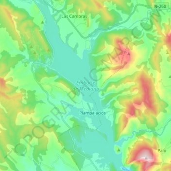
Name: Embalse de Mediano topographic map, elevation, terrain.
Average elevation: 2,129 ft
Minimum elevation: 1,493 ft
Maximum elevation: 3,793 ft
Other topographic maps
Click on a map to view its topography, its elevation and its terrain.
Barranco de Morillo
España > Aragón > Aínsa-Sobrarbe
Barranco de Morillo, Aínsa-Sobrarbe, Sobrarbe, Huesca, Aragón, 22349, España
Average elevation: 2,116 ft