
Willmar topographic map
Click on the map to display elevation.
About this map
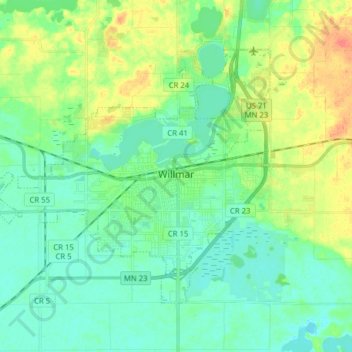
Name: Willmar topographic map, elevation, terrain.
Location: Willmar, Kandiyohi County, Minnesota, 56201, United States (45.08146 -95.15841 45.16113 -95.00157)
Average elevation: 1,145 ft
Minimum elevation: 1,099 ft
Maximum elevation: 1,250 ft
Kandiyohi County trails, hiking, mountain biking, running and outdoor activities
Other topographic maps
Click on a map to view its topography, its elevation and its terrain.
Mount Tom
United States > Minnesota > Kandiyohi County > Lake Andrew Township
Average elevation: 1,257 ft
Norway Lake
United States > Minnesota > Kandiyohi County > Arctander Township
Average elevation: 1,217 ft