
Mount Hobson topographic map
Interactive map
Click on the map to display elevation.
About this map
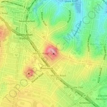
Name: Mount Hobson topographic map, elevation, terrain.
Location: Mount Hobson, Ōrākei, Auckland, 1050, New Zealand (-36.87834 174.78740 -36.87824 174.78750)
Average elevation: 217 ft
Minimum elevation: 7 ft
Maximum elevation: 459 ft
Other topographic maps
Click on a map to view its topography, its elevation and its terrain.
Waiatarua Reserve
New Zealand > Auckland > Orakei
Waiatarua Reserve, Meadowbank, Ōrākei, Auckland, New Zealand
Average elevation: 138 ft
Kepa Bush Reserve
New Zealand > Auckland > Orakei
Kepa Bush Reserve, Meadowbank, Ōrākei, Auckland, New Zealand
Average elevation: 112 ft
Glover Park
New Zealand > Auckland > Orakei
Glover Park, Saint Heliers, Ōrākei, Auckland, New Zealand
Average elevation: 43 ft
Orakei Domain
New Zealand > Auckland > Orakei
Orakei Domain, Orakei, Ōrākei, Auckland, New Zealand
Average elevation: 56 ft