
Thank you for supporting this site ❤️
Make a donation
Make a donation
Gear up for your next adventure:
As an Amazon Associate, this site earns from qualifying purchases at no extra cost to you.
Zapote topographic map
Click on the map to display elevation.
Thank you for supporting this site ❤️
Make a donation
Make a donation
Gear up for your next adventure:
As an Amazon Associate, this site earns from qualifying purchases at no extra cost to you.
Zapote
Zapote has an area of 2.87 km² and an elevation of 1,176 metres.
Thank you for supporting this site ❤️
Make a donation
Make a donation
Gear up for your next adventure:
As an Amazon Associate, this site earns from qualifying purchases at no extra cost to you.
About this map
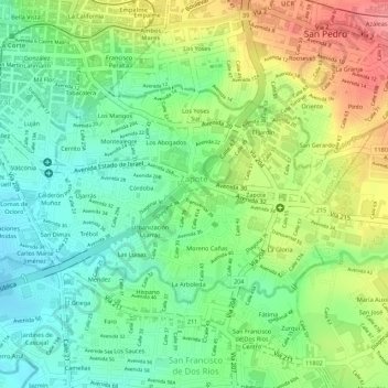
Name: Zapote topographic map, elevation, terrain.
Location: Zapote, Cantón San José, San Jose Province, 10105, Costa Rica (9.91276 -84.07168 9.92792 -84.04680)
Average elevation: 3,845 ft
Minimum elevation: 3,720 ft
Maximum elevation: 4,016 ft
Thank you for supporting this site ❤️
Make a donation
Make a donation
Gear up for your next adventure:
As an Amazon Associate, this site earns from qualifying purchases at no extra cost to you.