Geolocate

Locuto topographic map

Click on the map to display elevation.

About this map

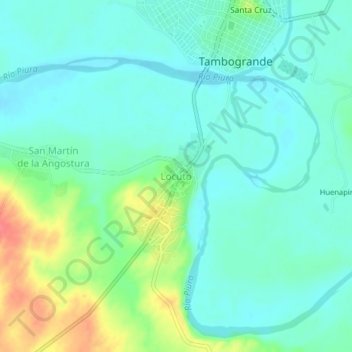
Name: Locuto topographic map, elevation, terrain.

Location: Locuto, Tambo Grande, Province of Piura, Piura, Peru (-4.96845 -80.36920 -4.92845 -80.32920)

Average elevation: 236 ft

Minimum elevation: 180 ft

Maximum elevation: 387 ft

Gear up for your next adventure:

🪶Wildlife Field Guides - Learn animal tracking and species ID
🧭Orienteering Set - Complete compass and map reading kit
🧦Hiking Socks - Comfortable socks to prevent blisters on long hikes
🕶️GPS Smartphone Mount - Secure mount for phone navigation
🧯Portable Fire Pit - Compact fire pit for camping spots

As an Amazon Associate, this site earns from qualifying purchases at no extra cost to you.