
Le Charachon topographic map
Interactive map
Click on the map to display elevation.
About this map
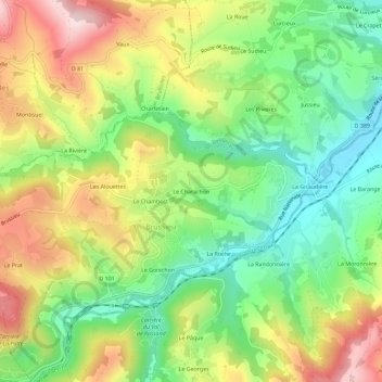
Name: Le Charachon topographic map, elevation, terrain.
Average elevation: 1,447 ft
Minimum elevation: 955 ft
Maximum elevation: 2,106 ft
Other topographic maps
Click on a map to view its topography, its elevation and its terrain.
Le Chambost
France > Auvergne-Rhône-Alpes > Rhône > Brussieu
Le Chambost, Brussieu, Lyon, Rhône, Auvergne-Rhône-Alpes, France métropolitaine, 69690, France
Average elevation: 1,486 ft