
Make a donation
Gear up for your next adventure:
As an Amazon Associate, this site earns from qualifying purchases at no extra cost to you.
Biskra topographic map
Click on the map to display elevation.
Make a donation
Gear up for your next adventure:
As an Amazon Associate, this site earns from qualifying purchases at no extra cost to you.
Biskra
Biskra is located in the north-east of Algeria, in the district of Biskra. The city lies about 248 miles (399 km) from Algiers, 71 miles (114 km) southwest of Batna and 137 miles (220 km) north of Touggourt. She is nicknamed "The Queen of the Zibans", "The door of the desert" or "The Saharan Nice" because of its location which is the beginning of the desert. It is located at an altitude of 87 m (285 ft) in the northern part of the Sahara Desert.
Make a donation
Gear up for your next adventure:
As an Amazon Associate, this site earns from qualifying purchases at no extra cost to you.
About this map
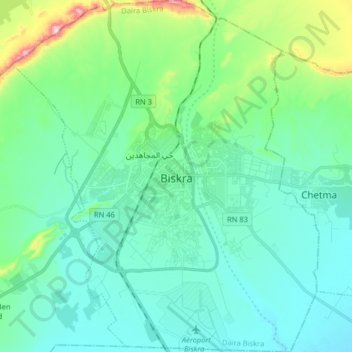
Name: Biskra topographic map, elevation, terrain.
Location: Biskra, Biskra District, Biskra, Algeria (34.78560 5.65367 34.91767 5.79383)
Average elevation: 420 ft
Minimum elevation: 197 ft
Maximum elevation: 1,378 ft
Make a donation
Gear up for your next adventure:
As an Amazon Associate, this site earns from qualifying purchases at no extra cost to you.