
Town of Dresden topographic map
Interactive map
Click on the map to display elevation.
About this map
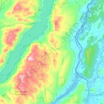
Name: Town of Dresden topographic map, elevation, terrain.
Location: Town of Dresden, Washington County, New York, United States (43.53374 -73.57899 43.69923 -73.39372)
Average elevation: 817 ft
Minimum elevation: 75 ft
Maximum elevation: 2,605 ft
Other topographic maps
Click on a map to view its topography, its elevation and its terrain.
Bald Mountain
United States > New York > Washington County
Bald Mountain, Washington County, New York, United States
Average elevation: 856 ft
Village of Cambridge
United States > New York > Washington County
Village of Cambridge, Town of White Creek, Washington County, New York, United States
Average elevation: 541 ft
Black Mountain
United States > New York > Washington County
Black Mountain, Town of Dresden, Washington County, New York, 12841, United States
Average elevation: 1,598 ft
West Hebron
United States > New York > Washington County > West Hebron
West Hebron, Town of Hebron, Washington County, New York, 12865, United States
Average elevation: 686 ft
Putnam Station
United States > New York > Washington County > Putnam Station
Putnam Station, Town of Putnam, Washington County, New York, United States
Average elevation: 272 ft
West Cambridge
United States > New York > Washington County > Town of Cambridge
West Cambridge, Town of Cambridge, Washington County, New York, United States
Average elevation: 653 ft
Village of Fort Edward
United States > New York > Washington County
Village of Fort Edward, Town of Fort Edward, Washington County, New York, United States
Average elevation: 171 ft