Geolocate

Estes Park topographic map

Click on the map to display elevation.

About this map

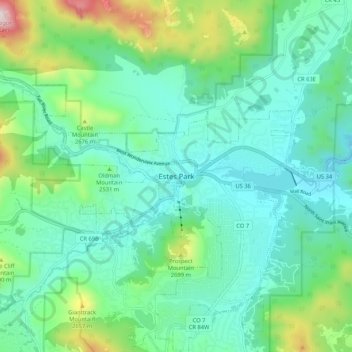
Name: Estes Park topographic map, elevation, terrain.

Location: Estes Park, Larimer County, Colorado, 80517, United States (40.33719 -105.56322 40.41719 -105.48322)

Average elevation: 8,074 ft

Minimum elevation: 7,372 ft

Maximum elevation: 10,453 ft

Larimer County trails, hiking, mountain biking, running and outdoor activities

Gear up for your next adventure:

🌐World Map Poster - Decorative world maps with topographic info
🏔️Mountain Trail Maps - High‑detail maps for popular peaks
🔦Compact Flashlight - Reliable flashlight for emergencies
🔌Solar Panel Charger - Charge gear sustainably outdoors
📚Navigation Handbooks - Master the art of reading topographic maps and using a compass

As an Amazon Associate, this site earns from qualifying purchases at no extra cost to you.