
Make a donation
Gear up for your next adventure:
As an Amazon Associate, this site earns from qualifying purchases at no extra cost to you.
Bojano topographic map
Click on the map to display elevation.
Make a donation
Gear up for your next adventure:
As an Amazon Associate, this site earns from qualifying purchases at no extra cost to you.
About this map
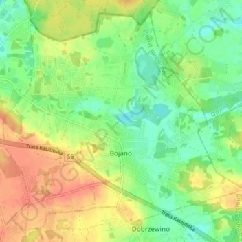
Name: Bojano topographic map, elevation, terrain.
Average elevation: 554 ft
Minimum elevation: 479 ft
Maximum elevation: 640 ft
Make a donation
Gear up for your next adventure:
As an Amazon Associate, this site earns from qualifying purchases at no extra cost to you.
Other topographic maps
Click on a map to view its topography, its elevation and its terrain.
Zbiornik Czymanowo
Poland > Pomeranian Voivodeship > Wejherowo County > Strzebielinek
Average elevation: 308 ft
Perlino-Wybudowa
Poland > Pomeranian Voivodeship > Wejherowo County > Perlino
Average elevation: 190 ft
Make a donation
Gear up for your next adventure:
As an Amazon Associate, this site earns from qualifying purchases at no extra cost to you.