
Make a donation
Gear up for your next adventure:
As an Amazon Associate, this site earns from qualifying purchases at no extra cost to you.
Stans topographic map
Click on the map to display elevation.
Make a donation
Gear up for your next adventure:
As an Amazon Associate, this site earns from qualifying purchases at no extra cost to you.
Stans
The area of Stans is 11.08 km2 (4.28 sq mi). Much of the land within the borders of Stans is agricultural (43.7%), while just over a third (36.5%) is forested. Of the remaining area, about 17% is settlements and less than 2.6% is unproductive (mountains, rivers or glaciers). The highest point within the borders of Stans is on the Stanserhorn and is 1,819 m (5,968 ft) above sea level. The lowest point is at Fronhofen where the elevation is 438 m (1,437 ft). The village square (Dorfplatz) has an elevation of 452 m (1,483 ft).
Make a donation
Gear up for your next adventure:
As an Amazon Associate, this site earns from qualifying purchases at no extra cost to you.
About this map
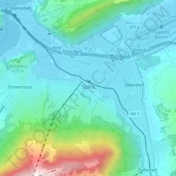
Name: Stans topographic map, elevation, terrain.
Location: Stans, Nidwalden, Switzerland (46.93129 8.34166 46.98193 8.38875)
Average elevation: 2,159 ft
Minimum elevation: 1,417 ft
Maximum elevation: 5,837 ft
Make a donation
Gear up for your next adventure:
As an Amazon Associate, this site earns from qualifying purchases at no extra cost to you.