
Stein am Rhein topographic map
Interactive map
Click on the map to display elevation.
About this map
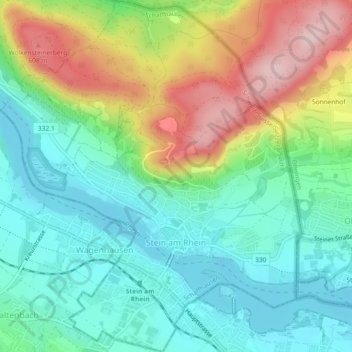
Name: Stein am Rhein topographic map, elevation, terrain.
Location: Stein am Rhein, Schaffhausen, 8260, Schweiz (47.65008 8.83684 47.68103 8.87615)
Average elevation: 1,555 ft
Minimum elevation: 1,280 ft
Maximum elevation: 2,087 ft
Other topographic maps
Click on a map to view its topography, its elevation and its terrain.
Enge
Schweiz > Schaffhausen > Neuhausen am Rheinfall
Enge, Neuhausen am Rheinfall, Schaffhausen, 8212, Schweiz
Average elevation: 1,558 ft
Stetten (SH)
Stetten (SH), Schaffhausen, 8234, Schweiz
Average elevation: 1,768 ft
Neuhausen am Rheinfall
Neuhausen am Rheinfall, Schaffhausen, 8212, Schweiz
Average elevation: 1,476 ft
Merishausen
Schweiz > Schaffhausen > Merishausen
Merishausen, Schaffhausen, 8232, Schweiz
Average elevation: 2,238 ft