
Pancevo City topographic map
Interactive map
Click on the map to display elevation.
About this map
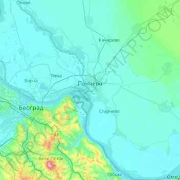
Name: Pancevo City topographic map, elevation, terrain.
Average elevation: 335 ft
Minimum elevation: 217 ft
Maximum elevation: 1,608 ft
Other topographic maps
Click on a map to view its topography, its elevation and its terrain.
City of Vršac
Serbia > Vojvodina > South Banat Administrative District
City of Vršac, South Banat Administrative District, Vojvodina, Serbia
Average elevation: 390 ft
Plandiste Municipality
Serbia > Vojvodina > South Banat Administrative District
Plandiste Municipality, South Banat Administrative District, Vojvodina, Serbia
Average elevation: 266 ft
Средњи врх
Serbia > Vojvodina > South Banat Administrative District > City of Vršac
Средњи врх, City of Vršac, South Banat Administrative District, Vojvodina, Serbia
Average elevation: 1,001 ft
Alibunar
Serbia > Vojvodina > South Banat Administrative District > Alibunar Municipality > Alibunar
Alibunar, Alibunar Municipality, South Banat Administrative District, Vojvodina, 26310, Serbia
Average elevation: 331 ft