
Encarnación topographic map
Interactive map
Click on the map to display elevation.
About this map
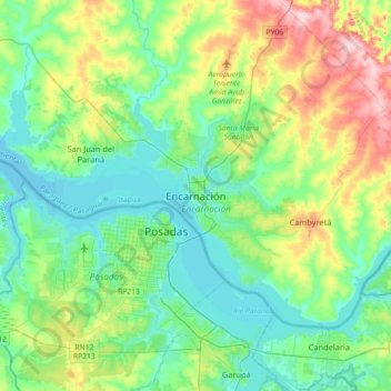
Name: Encarnación topographic map, elevation, terrain.
Location: Encarnación, Itapúa, Región Oriental, 6000, Paraguay (-27.49761 -56.02695 -27.17761 -55.70695)
Average elevation: 427 ft
Minimum elevation: 243 ft
Maximum elevation: 932 ft
Die Stadt gliederte sich ursprünglich in zwei Gebiete, den höher gelegenen modernen Teil (auch finanzielles Zentrum der Stadt), sowie die Altstadt in unmittelbarer Umgebung des Río Paraná. Unter den rund 130.000 Einwohnern (Stand 2017) finden sich viele deutscher, japanischer, arabischer, ukrainischer, neuseeländischer, chinesischer und auch polnischer Abstammung.
Other topographic maps
Click on a map to view its topography, its elevation and its terrain.
Encarnación
Paraguay > Itapúa > Encarnación
Encarnación, Itapúa, Región Oriental, 6000, Paraguay
Average elevation: 463 ft