
Morticcio Di Cava topographic map
Interactive map
Click on the map to display elevation.
About this map
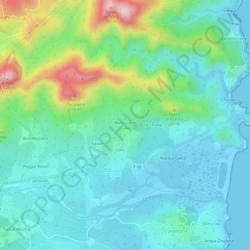
Name: Morticcio Di Cava topographic map, elevation, terrain.
Average elevation: 266 ft
Minimum elevation: -7 ft
Maximum elevation: 1,145 ft
Other topographic maps
Click on a map to view its topography, its elevation and its terrain.
Fautea
France > Corse > Corse-du-Sud > Zonza
Fautea, Zonza, Sartène, Corse-du-Sud, Corse, France métropolitaine, France
Average elevation: 138 ft
Col de Bavella
France > Corse > Corse-du-Sud > Zonza
Col de Bavella, D 268, Zonza, Sartène, Corse-du-Sud, Corse, France métropolitaine, 20124, France
Average elevation: 3,684 ft