
Village of Ilion topographic map
Interactive map
Click on the map to display elevation.
About this map
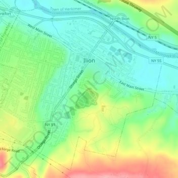
Name: Village of Ilion topographic map, elevation, terrain.
Average elevation: 495 ft
Minimum elevation: 354 ft
Maximum elevation: 745 ft
Other topographic maps
Click on a map to view its topography, its elevation and its terrain.
Village of Mohawk
United States > New York > Herkimer County > Town of German Flatts
Village of Mohawk, Town of German Flatts, Herkimer County, New York, United States
Average elevation: 486 ft
Dennison Corners
United States > New York > Herkimer County > Town of German Flatts
Dennison Corners, Town of German Flatts, Herkimer County, New York, 13407, United States
Average elevation: 1,325 ft
Edicks
United States > New York > Herkimer County > Town of German Flatts
Edicks, Town of German Flatts, Herkimer County, New York, United States
Average elevation: 1,165 ft
South Ilion
United States > New York > Herkimer County > Town of German Flatts
South Ilion, Town of German Flatts, Herkimer County, New York, United States
Average elevation: 784 ft
Days Rock
United States > New York > Herkimer County > Town of German Flatts
Days Rock, Town of German Flatts, Herkimer County, New York, 13407, United States
Average elevation: 1,040 ft
Fort Herkimer
United States > New York > Herkimer County > Town of German Flatts
Fort Herkimer, Town of German Flatts, Herkimer County, New York, 13350, United States
Average elevation: 581 ft