Geolocate

Woolwine topographic map

Click on the map to display elevation.

About this map

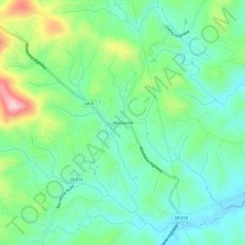
Name: Woolwine topographic map, elevation, terrain.

Location: Woolwine, Patrick County, Virginia, 24185, United States (36.76986 -80.29728 36.80986 -80.25728)

Average elevation: 1,490 ft

Minimum elevation: 1,234 ft

Maximum elevation: 2,123 ft

Patrick County trails, hiking, mountain biking, running and outdoor activities

Other topographic maps

Click on a map to view its topography, its elevation and its terrain.

Stuart

United States > Virginia > Patrick County

Average elevation: 1,348 ft

Fairy Stone Lake

United States > Virginia > Patrick County

Average elevation: 1,109 ft

Stuart

United States > Virginia > Patrick County

Average elevation: 1,365 ft

Patrick Springs

United States > Virginia > Patrick County

Average elevation: 1,276 ft

Stuart

United States > Virginia > Patrick County

Average elevation: 1,348 ft

Gear up for your next adventure:

🎒Trekking Poles - Sturdy poles for balance and stability on rough terrain
🗺️NatGeo Topo Maps - High-quality waterproof printed topographic maps of US Parks
🎒Outdoor Daypacks - Lightweight backpacks designed for carrying maps and essential gear
🪑Portable Camp Table - Compact table for campsite meals
🔥Plasma Lighters - Windproof lighters that work in any weather condition

As an Amazon Associate, this site earns from qualifying purchases at no extra cost to you.