
Dornach topographic map
Interactive map
Click on the map to display elevation.
About this map
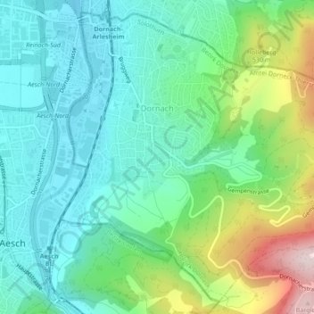
Name: Dornach topographic map, elevation, terrain.
Average elevation: 1,302 ft
Minimum elevation: 922 ft
Maximum elevation: 2,320 ft
Other topographic maps
Click on a map to view its topography, its elevation and its terrain.
Hochwald
Switzerland > Solothurn > Amtei Dorneck-Thierstein
Hochwald, Bezirk Dorneck, Amtei Dorneck-Thierstein, Solothurn, 4146, Switzerland
Average elevation: 2,018 ft
Witterswil
Switzerland > Solothurn > Amtei Dorneck-Thierstein > Witterswil
Witterswil, Bezirk Dorneck, Amtei Dorneck-Thierstein, Solothurn, 4108, Switzerland
Average elevation: 1,257 ft