
Make a donation
Gear up for your next adventure:
As an Amazon Associate, this site earns from qualifying purchases at no extra cost to you.
Cuyabeno topographic map
Click on the map to display elevation.
Make a donation
Gear up for your next adventure:
As an Amazon Associate, this site earns from qualifying purchases at no extra cost to you.
About this map
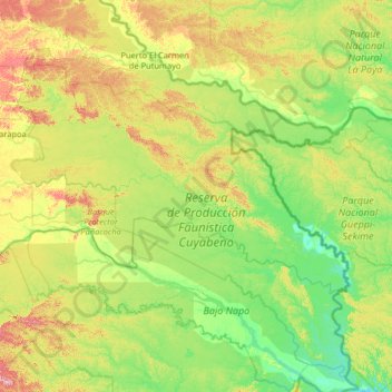
Name: Cuyabeno topographic map, elevation, terrain.
Location: Cuyabeno, Sucumbíos, 210304, Ecuador (-0.65617 -76.51850 -0.01208 -75.22331)
Average elevation: 709 ft
Minimum elevation: 545 ft
Maximum elevation: 1,165 ft
Make a donation
Gear up for your next adventure:
As an Amazon Associate, this site earns from qualifying purchases at no extra cost to you.
Other topographic maps
Click on a map to view its topography, its elevation and its terrain.
Cordillera de la Bretaña
Ecuador > Sucumbíos > Sucumbíos > El Playón de San Francisco
Average elevation: 5,853 ft
Inmortal Simón Bolívar
Ecuador > Sucumbíos > Nueva Loja > Inmortal Simón Bolívar
Average elevation: 984 ft
Make a donation
Gear up for your next adventure:
As an Amazon Associate, this site earns from qualifying purchases at no extra cost to you.