
Fraser topographic map
Interactive map
Click on the map to display elevation.
About this map
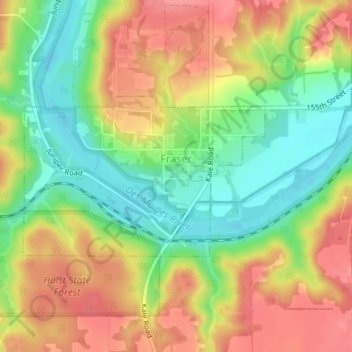
Name: Fraser topographic map, elevation, terrain.
Location: Fraser, Boone County, Iowa, United States (42.11898 -93.98439 42.13127 -93.95933)
Average elevation: 1,007 ft
Minimum elevation: 873 ft
Maximum elevation: 1,135 ft
Other topographic maps
Click on a map to view its topography, its elevation and its terrain.
Boxholm
United States > Iowa > Boone County
Boxholm, Boone County, Iowa, 50040, United States
Average elevation: 1,135 ft
Centerville
United States > Iowa > Boone County
Centerville, Boone County, Iowa, United States
Average elevation: 1,030 ft
Beaver
United States > Iowa > Boone County
Beaver, Boone County, Iowa, United States
Average elevation: 1,014 ft
Ogden
United States > Iowa > Boone County
Ogden, Boone County, Iowa, 50212, United States
Average elevation: 1,083 ft
Boone
United States > Iowa > Boone County
Boone, Boone County, Iowa, 50036, United States
Average elevation: 1,112 ft
Ledges State Park
United States > Iowa > Boone County
Ledges State Park, Boone County, Iowa, United States
Average elevation: 1,010 ft
Fraser
United States > Iowa > Boone County > Fraser > Fraser
Fraser, Boone County, Iowa, 50223, United States
Average elevation: 1,040 ft
Berkley
United States > Iowa > Boone County
Berkley, Boone County, Iowa, United States
Average elevation: 988 ft
Luther
United States > Iowa > Boone County
Luther, Boone County, Iowa, 50152, United States
Average elevation: 1,093 ft
Pilot Mound
United States > Iowa > Boone County
Pilot Mound, Boone County, Iowa, United States
Average elevation: 1,115 ft