
Fraser topographic map
Click on the map to display elevation.
About this map
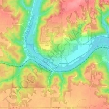
Name: Fraser topographic map, elevation, terrain.
Location: Fraser, Boone County, Iowa, 50223, United States (42.10649 -93.98855 42.14649 -93.94855)
Average elevation: 1,040 ft
Minimum elevation: 869 ft
Maximum elevation: 1,181 ft
Boone County trails, hiking, mountain biking, running and outdoor activities