
Make a donation
Gear up for your next adventure:
As an Amazon Associate, this site earns from qualifying purchases at no extra cost to you.
Pembroke topographic map
Click on the map to display elevation.
Make a donation
Gear up for your next adventure:
As an Amazon Associate, this site earns from qualifying purchases at no extra cost to you.
Pembroke
Pembroke Parish is located in the central part of the main island of Bermuda. It is bordered by Devonshire Parish to the east. The parish covers an area of approximately 2.1 sq mi (5.4 km2) and has a coastline along the North Shore and Hamilton Harbour. The topography of the country is generally undulating, characterized by low cliffs and beaches. The limestone cliffs, which has been shaped by wind and water over millennia, create a rugged coastline with numerous small caves.
Make a donation
Gear up for your next adventure:
As an Amazon Associate, this site earns from qualifying purchases at no extra cost to you.
About this map
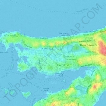
Name: Pembroke topographic map, elevation, terrain.
Location: Pembroke, Bermuda (32.28930 -64.82061 32.30893 -64.77069)
Average elevation: 30 ft
Minimum elevation: -3 ft
Maximum elevation: 213 ft
Make a donation
Gear up for your next adventure:
As an Amazon Associate, this site earns from qualifying purchases at no extra cost to you.
Other topographic maps
Click on a map to view its topography, its elevation and its terrain.
Make a donation
Gear up for your next adventure:
As an Amazon Associate, this site earns from qualifying purchases at no extra cost to you.
Make a donation
Gear up for your next adventure:
As an Amazon Associate, this site earns from qualifying purchases at no extra cost to you.