Geolocate

Highland topographic map

Click on the map to display elevation.

About this map

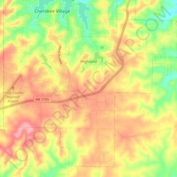
Name: Highland topographic map, elevation, terrain.

Location: Highland, Sharp County, Arkansas, United States (36.23402 -91.56596 36.29620 -91.47898)

Average elevation: 636 ft

Minimum elevation: 427 ft

Maximum elevation: 804 ft

Sharp County trails, hiking, mountain biking, running and outdoor activities

Other topographic maps

Click on a map to view its topography, its elevation and its terrain.

Ozark Acres

United States > Arkansas > Sharp County

Average elevation: 581 ft

Gear up for your next adventure:

📖Nature Tracking Books - Learn to track wildlife and terrain
🧣Hiking Neck Gaiter - Multi‑use neck protection for outdoor weather
📚USA Hiking Guide Books - Top trail guides and map books
🛶Inflatable Kayak - Portable kayak for rivers, lakes, and expeditions
🔋Rechargeable Batteries - Power up your outdoor devices

As an Amazon Associate, this site earns from qualifying purchases at no extra cost to you.