Geolocate

Fort Mill topographic map

Click on the map to display elevation.

About this map

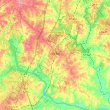
Name: Fort Mill topographic map, elevation, terrain.

Location: Fort Mill, York County, South Carolina, United States (34.94577 -80.98052 35.06615 -80.89695)

Average elevation: 587 ft

Minimum elevation: 436 ft

Maximum elevation: 728 ft

York County trails, hiking, mountain biking, running and outdoor activities

Other topographic maps

Click on a map to view its topography, its elevation and its terrain.

Lake Wylie

United States > South Carolina > York County

Average elevation: 617 ft

Blairsville

United States > South Carolina > York County

Average elevation: 577 ft

Pineview

United States > South Carolina > York County > York

Average elevation: 712 ft

Gear up for your next adventure:

🧢Outdoor Hiking Hat - Sun protection hat for outdoor explorers
🔪Outdoor Multitools - Essential survival tools for gear repair and field use
🧣Merino Neck Gaiters - Multi-functional headwear for wind and sun protection
🪶Survival Guide Book - Expert advice for emergency preparedness
🎒Outdoor Daypacks - Lightweight backpacks designed for carrying maps and essential gear

As an Amazon Associate, this site earns from qualifying purchases at no extra cost to you.