Geolocate

Lanusei topographic map

Click on the map to display elevation.

About this map
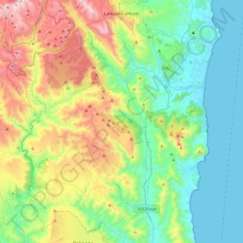
Name: Lanusei topographic map, elevation, terrain.

Location: Lanusei, Nuoro, Sardinia, 08045, Italy (39.60305 9.49021 39.89425 9.65529)

Average elevation: 1,273 ft

Minimum elevation: 0 ft

Maximum elevation: 4,311 ft

Other topographic maps

Click on a map to view its topography, its elevation and its terrain.
Biddanoa

Italy > Sardinia > Nuoro > Torpè

Average elevation: 295 ft

Cala Gonone

Italy > Sardinia > Nuoro

Average elevation: 463 ft

Montelongu

Italy > Sardinia > Nuoro > San Giovanni

Average elevation: 39 ft

Gorofai

Italy > Sardinia > Nuoro > Bitzi/Bitti

Average elevation: 1,939 ft

Cala Luna

Italy > Sardinia > Nuoro > Durgali/Dorgali

Average elevation: 249 ft

Pirastreri

Italy > Sardinia > Nuoro > Thiniscole/Siniscola

Average elevation: 194 ft

Cala Luna

Italy > Sardinia > Nuoro > Durgali/Dorgali

Average elevation: 249 ft

Gear up for your next adventure:

🛏️Cold Weather Sleeping Bag - Warm sleeping bag for cold conditions
🪄Magnetic Compass - Accurate compass for navigation
🧭Map Reading Tools - Tools and kits for map navigation
📻Weather Alert Radios - Stay informed of storm risks while off-the-grid
🪶Survival Guide Book - Expert advice for emergency preparedness

As an Amazon Associate, this site earns from qualifying purchases at no extra cost to you.