
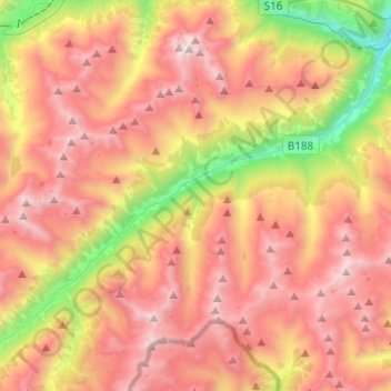
Gemeinde Kappl topographic map
Interactive map
Click on the map to display elevation.
About this map
Name: Gemeinde Kappl topographic map, elevation, terrain.
Location: Gemeinde Kappl, Bezirk Landeck, Tyrol, Austria (46.99061 10.28676 47.11622 10.53075)
Average elevation: 7,011 ft
Minimum elevation: 3,330 ft
Maximum elevation: 10,266 ft
Other topographic maps
Click on a map to view its topography, its elevation and its terrain.
Arlberg
Austria > Tyrol > Bezirk Landeck > St. Christoph
Arlberg, St. Christoph, Sankt Anton am Arlberg, Bezirk Landeck, Tyrol, 6580, Austria
Average elevation: 6,440 ft
Gemeinde Nauders
Austria > Tyrol > Bezirk Landeck > Gemeinde Nauders
Gemeinde Nauders, Bezirk Landeck, Tyrol, 6543, Austria
Average elevation: 6,654 ft