
Providence topographic map
Interactive map
Click on the map to display elevation.
About this map
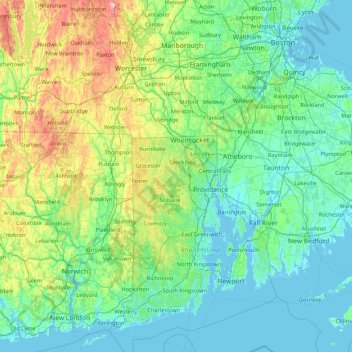
Name: Providence topographic map, elevation, terrain.
Location: Providence, Rhode Island, 02828, USA (41.22774 -72.22148 42.50774 -70.94148)
Average elevation: 285 ft
Minimum elevation: -26 ft
Maximum elevation: 1,893 ft
Other topographic maps
Click on a map to view its topography, its elevation and its terrain.
Snake Den
USA > Rhode Island > Johnston
Snake Den, Johnston, Providence, Rhode Island, 02919, USA
Average elevation: 295 ft
Beavertail State Park
USA > Rhode Island > Jamestown
Beavertail State Park, Jamestown, Newport, Rhode Island, USA
Average elevation: 7 ft
Badger Mountain
USA > Rhode Island > Burrillville
Badger Mountain, Burrillville, Providence, Rhode Island, USA
Average elevation: 623 ft
Killingly Pond
USA > Rhode Island > Glocester
Killingly Pond, Dam Road, Glocester, Windham County, Rhode Island, 06243, USA
Average elevation: 633 ft
Ninigret National Wildlife Refuge
USA > Rhode Island > Charlestown
Ninigret National Wildlife Refuge, Charlestown, Washington, Rhode Island, USA
Average elevation: 3 ft
Narragansett Bay National Estuarine Research Reserve
USA > Rhode Island > Portsmouth
Narragansett Bay National Estuarine Research Reserve, 55, Portsmouth, Newport, Rhode Island, 02872, USA
Average elevation: 33 ft
Audubon Society
Audubon Society, North Lane, North Farm on the Bay, Bristol, Rhode Island, 02885, USA
Average elevation: 46 ft
Rhode Island Sound
USA > Rhode Island > Little Compton
Rhode Island Sound, Rhode Island Road, Little Compton, Newport, Rhode Island, 02837, USA
Average elevation: 0 ft
Norman Bird Sanctuary
USA > Rhode Island > Middletown
Norman Bird Sanctuary, Middletown, Newport, Rhode Island, 02842, USA
Average elevation: 52 ft